Add to collection
  • + Create new collection
  • Rights: University of Waikato. All Rights Reserved.
    Published 27 March 2013 Referencing Hub media
    Download

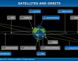
    Name: COSMIC/FORMOSAT-3

    Owner: Taiwan/USA

    Mission: science – meteorological data1 collection

    Launch date: 2006

    Type of orbit: low-Earth orbit2, non-Sun-synchronous

    Period: 100 minutes

    Perigee: 496 km

    Apogee: 540 km

    Transcript

    Dr Adrian McDonald

    The satellite3 that I use mostly to measure temperature4 is something called COSMIC/FORMOSAT-3. It’s not actually one satellite, it’s a constellation5 of six low-Earth orbiting satellites so they’re about 500 kilometres away from the Earth’s surface. And what those satellites do is look at signals from the GPS6 satellites. Those signals can be used to make measurements of temperature, and that’s associated with the fact that, if we look from our low-Earth orbiting satellite forward towards our GPS satellite, rather than that path being perfectly straight, it’s slightly bent, so it’s refracted.

    And that small bending angle, you can measure that because you know the GPS satellite’s got a very accurate clock on it, and that very accurate clock allows you to time the measurement from the GPS satellite to the low-Earth orbiting COSMIC/FORMOSAT satellite. And by knowing the time, and we know that the fact of the speed of light is a constant, we can work out the distance, and therefore our distance is a curved path rather than a straight path, and the level of curvature of the path tells us about the temperature, because refraction7 is controlled by the temperature of the atmosphere8.

    1. data: The unprocessed information we analyse to gain knowledge.
    2. orbit: The path of an object as it revolves around another object. For example, the path the Moon takes as it moves around the Earth is its orbit.
    3. satellite: Any object that orbits around another object.
    4. temperature: A measure of the degree of hotness or coldness of an object or substance. Temperature is measured with a thermometer calibrated in one or more temperature scales. Kelvin scale temperature is a measure of the average energy of the molecules of a body.
    5. constellation: An area of the night sky that contains a group of stars that seems to form a certain shape or picture.
    6. GPS: Global positioning system. Uses satellites, computers and receivers to determine the exact position of a receiver on Earth by calculating the time difference for signals from different satellites to reach the receiver.
    7. refraction: The bending of a wave as it passes from one medium to another. Refraction signifies a change in velocity (speed) of the wave.
    8. atmosphere: 1. The layer of gas around the Earth. 2. (atm) A non-SI unit of pressure equivalent to 101.325 kPa.
      Go to full glossary
      Download all

      data

    1. + Create new collection
    2. The unprocessed information we analyse to gain knowledge.

      temperature

    3. + Create new collection
    4. A measure of the degree of hotness or coldness of an object or substance. Temperature is measured with a thermometer calibrated in one or more temperature scales. Kelvin scale temperature is a measure of the average energy of the molecules of a body.

      refraction

    5. + Create new collection
    6. The bending of a wave as it passes from one medium to another. Refraction signifies a change in velocity (speed) of the wave.

      orbit

    7. + Create new collection
    8. The path of an object as it revolves around another object. For example, the path the Moon takes as it moves around the Earth is its orbit.

      constellation

    9. + Create new collection
    10. An area of the night sky that contains a group of stars that seems to form a certain shape or picture.

      atmosphere

    11. + Create new collection
    12. 1. The layer of gas around the Earth.

      2. (atm) A non-SI unit of pressure equivalent to 101.325 kPa.

      satellite

    13. + Create new collection
    14. Any object that orbits around another object.

      GPS

    15. + Create new collection
    16. Global positioning system. Uses satellites, computers and receivers to determine the exact position of a receiver on Earth by calculating the time difference for signals from different satellites to reach the receiver.