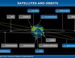
Name: CryoSat-2
Owner: European Space Agency
Mission: environmental – measuring ice thickness
Launch date: 2010
Type of orbit: low-Earth orbit, non-Sun-synchronous
Period: 99 minutes
Perigee: 720 km
Apogee: 732 km
Transcript
Dr Wolfgang Rack
CryoSat-2 is at the moment the only satellite which is solely dedicated for ice research. It’s in a polar orbit, it is about 700 kilometres above the Earth’s surface. CryoSat-2 is a fairly small satellite because it is a very specialised satellite mission, and the main instrument is an improved version of a radar altimeter, which can measure the surface elevation at a much higher accuracy than previous radar altimeters. And very important for an accurate measurement of surface elevation is the position of the satellite, and therefore there is a second important instrument on this satellite, which actually measures very accurately the position of the orbit.
The satellites flies with the ground speed of about 7 kilometres per second. So along this drag, we get sea ice thickness measurements, which are about 1 kilometre wide along that orbit, and those orbits are separated by several kilometres from one orbit pass to the next. So it’s built up, we get this information from ice thickness quite quickly.