An artificial satellite1 is an object that people have made and launched into orbit2 using rockets. There are currently over 3,000 active satellites orbiting the Earth. The size, altitude3 and design of a satellite depend on its purpose.
Sizes and altitudes of satellites
Satellites vary in size. Some cube satellites are as small as 10 cm. Some communication satellites are about 7 m long and have solar panels that extend another 50 m. The largest artificial satellite is the International Space Station (ISS). The main part of this is as big as a large five-bedroom house, but including solar panels, it is as large as a rugby field.
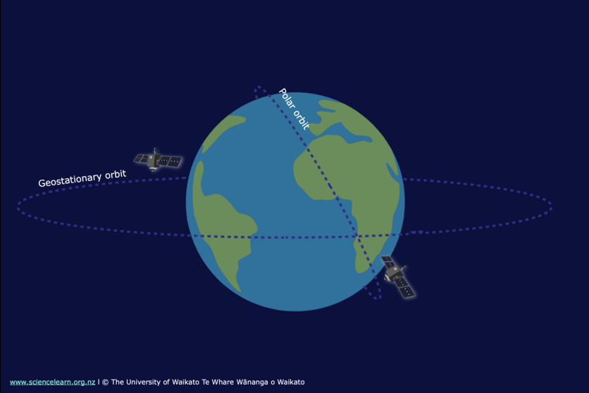
Altitudes of satellites above the Earth’s surface also vary. These are three common orbits:
- Low Earth orbit (LEO) – from 200 to 2,000 km, for example, the ISS orbits at 400 km with a speed of 28,000 km/hour, and time for one orbit is about 90 minutes.
- Medium Earth orbit (MEO) – most MEO satellites are at an altitude of 20,000 km, and time for one orbit is 12 hours.
- Geostationary orbit (GEO) – 36,000 km above the Earth. Time for one orbit is 24 hours. This is to match the rotation of the Earth so that the satellite appears to stay above the same point above the Earth’s surface. This is used for many communications and weather4 satellites.
The altitude chosen for a satellite depends on the job it is designed for.
Types of satellites
Navigation satellites
The GPS (global positioning system) is made up of a minimum of 24 satellites (and allows for up to 32), that orbit at an altitude of 20,000 km above the surface of the Earth. The difference in time for signals received from four satellites is used to calculate the exact location of a GPS5 receiver on Earth.
Communication satellites
These are used for television, phone or internet transmissions, for example, the Optus D1 satellite is in a geostationary orbit6 above the equator and has a coverage footprint7 to provide signals to all of Australia and New Zealand.
Weather satellites
These are used to image clouds and measure temperature8 and rainfall. Both geostationary and low Earth orbits are used depending on the type of weather satellite. Weather satellites are used to help with more accurate weather forecasting9.
Earth observation satellites
These are used to photograph and image the Earth. Low Earth orbits are mainly used so that a more detailed image can be produced.
Astronomical satellites
These are used to monitor and image space. A satellite such as the James Webb Space Telescope provides very sharp images of stars and distant galaxies. It operates in a halo orbit – between about 250,000 and 832,000 km, which keeps it out of both Earth and Moon's shadow10. Other space telescopes include Hubble and Chandra.
International Space Station (ISS)
This is a habitable space laboratory. At an altitude of 400 km, the ISS travels at a speed of 28,000 km/h and orbits the Earth once every 92 minutes. Scientists inside the ISS are able to perform many valuable experiments in a microgravity environment.
Satellite design
Every satellite has some of the same basic parts:
- The bus – this is the frame and structure of the satellite to which all the other parts are attached.
- A power source – most satellites have solar panels to generate electricity11. Batteries store some of this energy for times that the satellite is in the shadow of the Earth.
- Heat control system – satellites are exposed to extremely high temperatures due to exposure to the Sun. There needs to be a way to reflect and reradiate heat12. Electrical components of the satellite can also produce a lot of heat.
- Computer system – satellites need computers to control how they operate and also to monitor things like altitude, orientation and temperature.
- Communication system – all satellites need to be able to send and receive data13 to ground stations on Earth or to other satellites. Curved satellite dishes are used as antennae14
- Attitude control system – this is the system that keeps a satellite pointed in the right direction. Gyroscopes and rocket thrusters are commonly used to change orientation. Light sensors are commonly used to determine what direction a satellite is pointing.
- A propulsion system – a rocket engine on the satellite may be used to help place the satellite into the correct orbit. Once in orbit, satellites do not need any rockets to keep them moving. However, small rockets called thrusters are used if a satellite needs to change orbit slightly.
As well as these basic parts, satellites carry the equipment needed for their specific purpose.
Making space accessible
To get a satellite into space is a very expensive business that few can afford. Rocket Lab, a company set up by New Zealander Peter Beck, was set up with a vision to “make space more accessible”.
Peter has a vision that affordable access to space will enable powerful global change – for example allowing developing nations better access to internet. In 2012, Peter initiated the Electron programme to focus on providing cost effective rockets and launch services that will allow organisations better access to space and satellite technology.
Nature of science
The operation of the International Space Station depends upon collaboration15 between countries. It allows scientists to pool their resources in terms of scientific knowledge and finances. As a result, bigger and more substantial projects can be conducted to get more reliable results. This research is of benefit internationally.
Related content
Read about natural satellites, communications satellites and learn about how satellites are launched into space and how some of them have become space junk.
Activity ideas
Get your students turn their eyes to the night sky to observe natural satellites and to spot artificial satellites – like the ISS – as they pass overhead. Back indoors, students can hunt for satellites online with a webquest.
Four activities use models to teach science concepts.
- Build a 3D model of a satellite, complete with solar panels, and aerial and outer casing for heat control16.
- Make a model CubeSat and micro:bit sun sensor is ideal for showing the tiny size and complexity of a 1U CubeSat.
- Scale model for satellite orbits explores satellite altitudes and satellite motion.
- Investigating satellite dishes uses an umbrella as a curved reflector to increase a cellphone's Wi-Fi signal.
Find out more about what is in an Earth observation satellite? What keeps it powered, on track, safe from danger and enables it to collect data? Find out for yourself with the Build a satellite interactive and activity!
Useful links
Information and some images from the Geoeye-1 satellite.
Find out more about the International Space Station from NASA.
This Stuff news story from November 2016, covers the announcement of the launch of New Zealand’s second Regional Research Institute, The Centre for Space Science Technology, will explore the use of space-based measurements and satellite imagery. See the centre's website.
NASA's Eyes on the Earth site shows the positions of their Earth observation satellites. Use the tabs at the bottom of the page to filter for greenhouse gases17 and other measurements.
- satellite: Any object that orbits around another object.
- orbit: The path of an object as it revolves around another object. For example, the path the Moon takes as it moves around the Earth is its orbit.
- altitude: 1. The height of something, usually height above sea level. 2. In astronomy, the angular distance of a natural or artificial satellite above the horizon.
- weather: Daily or short-term conditions like temperature, cloud cover, precipitation and wind affecting a certain area.
- GPS: Global positioning system. Uses satellites, computers and receivers to determine the exact position of a receiver on Earth by calculating the time difference for signals from different satellites to reach the receiver.
- geostationary orbit: A type of orbit high above the equator where a satellite appears to remain above the same point on the Earth’s surface because the orbital period of the satellite is the same as the rate of rotation of the Earth.
- footprint: 1. The area of land a building or facility occupies.
2. An impact that humans have on the environment.
3. In aerospace, an area in which a spacecraft or space debris may land. - temperature: A measure of the degree of hotness or coldness of an object or substance. Temperature is measured with a thermometer calibrated in one or more temperature scales. Kelvin scale temperature is a measure of the average energy of the molecules of a body.
- weather forecast: Using data to predict daily or short-term conditions such as temperature, cloud cover, precipitation and wind affecting a certain area or the estimate of a future weather event or series of events.
- shadow: A dark image produced when an object blocks rays of light from reaching a surface.
- electricity: A general term that includes a variety of phenomena resulting from the presence and flow of electrical charge.
- heat energy (heat): Heat energy: the transfer of energy in materials from the random movement of the particles in that material. The greater the random movement of particles the more heat energy the material has. Temperature is a measure of the heat energy of a material.
Heat: the flow of energy from a warm object to a cooler object. - data: The unprocessed information we analyse to gain knowledge.
- antenna: In physics a device used to transmit or receive electromagnetic signals such as for radio or television. Also known as an aerial. A satellite dish is a type of antenna. In biology antennae are sensory appendages that occur in pairs on the heads of insects and many other arthropods. Antenna refers to one of the jointed, movable appendages.
- collaboration: Working together with a common purpose.
- control: 1. Part of a scientific experiment in which no treatment has been applied in order to see whether there are any detectable differences to the experiment that did receive a treatment. 2. To hold in check or to curb.
- greenhouse gases: A natural or manmade gas that traps heat in the Earth's atmosphere and contributes to the greenhouse effect. The main greenhouse gases are water vapour, carbon dioxide (CO2), methane (CH4), nitrous oxide (N2O), ozone and industrial gases such as chlorofluorocarbons (CFCs). These gases in the Earth's atmosphere trap warmth from the Sun and make life possible. An overabundance of greenhouse gases leads to a rise in global temperatures – known as the greenhouse effect.
