In 2008, scientists, Civil Defence, electricity1 companies, transport providers and government came together in a major exercise to find out how a theoretical volcanic eruption might impact Auckland and how the effects of an eruption could be managed.
In Māori mythology, Ruaumoko is the god of volcanoes and seasons. When the scientists began this major project to find out how good they were at predicting a possible future eruption, they decided that Ruaumoko was a very appropriate name.
What did Exercise Ruaumoko involve?
Scientists at the Institute of Geological and Nuclear Sciences (GNS) wrote a scenario that described an imaginary volcanic eruption occurring somewhere in New Zealand. Then they began to share this information, piece by piece, with the project team.
Scientists on the team had no idea where the volcano was, when it was going to erupt and how it was going to erupt. It was their job to read the data2 given to them by GNS and try and predict the outcomes. Their interpretations of the data needed to be accurate and quick enough to allow Civil Defence and the government officials on the team the time to act. How did they do it?
Monitoring volcanic eruptions

Scientists like Dr Jan Lindsay at The University of Auckland are experts at reading volcanoes. They look for tell-tale signs in the data that an eruption is coming:
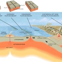
- Seismometer data: Seismometers are devices that are placed around the earth to ‘listen’ for seismic waves, which are associated with tectonic plate3 movement. Generally we associate this movement with earthquakes, but volcanic eruptions can also cause seismic waves. The seismic waves can be detected on the network of seismographs maintained around the country by GeoNet – the nationwide system of monitoring geological hazards in New Zealand. Scientists on Exercise Ruaumoko needed to identify seismometer data that could provide an essential early warning of lava4 starting to move through the ground to the surface.
- Ground deformation: The lava pushing from underneath causes the ground to buckle. With modern technology, the shape of the ground is being constantly monitored, often by satellites (via GPS5). If the shape of the ground starts to bulge or dip, then the scientists will be looking for other signs of a possible eruption. Scientists on Exercise Ruaumoko looked at GPS data to monitor ground movement. Ground changes are an important clue in the puzzle for Auckland, as there is no way of predicting where the next vent6 will form.
- Gas monitoring: Rising magma7 can release many different gases8. Changes in the composition of these gases can reflect changes that are happening down in the magma chamber9. Scientists measure what is happening or changing by collecting and analysing these gases, or water from crater lakes. This type of monitoring is particularly important for volcanoes such as Ruapehu or White Island where there is an obvious vent. In Auckland, scientists will need to wait for a vent to form, but after it forms, they will be able to monitor the gases released from the vent to gather information about further eruptions.
So how did the team do?
The Ruaumoko team used the data that was fed through in the simulation and successfully predicted the location of the theoretical volcano and were able to plan the evacuation of an area in time. Of course, this was only a practice run, but it is good to know that the city and the scientists are prepared.
Activity idea
In the Who’s on your team? activity, students work in small groups to select a 6-member disaster response team from a set of 12 biography cards.
- electricity: A general term that includes a variety of phenomena resulting from the presence and flow of electrical charge.
- data: The unprocessed information we analyse to gain knowledge.
- tectonic plate: One of several large sections of the Earth’s crust. The Earth’s surface consists of six big tectonic plates and several smaller ones.
- lava: Magma that has erupted from a volcano and has come to the surface.
- GPS: Global positioning system. Uses satellites, computers and receivers to determine the exact position of a receiver on Earth by calculating the time difference for signals from different satellites to reach the receiver.
- vent: The area of a volcano where the magma is able to push through in an eruption. One volcano may contain several vents.
- magma: Molten rock that is found under the Earth and has not reached the surface. Formed from the Earth’s mantle and forms the lava that erupts from volcanoes.
- gases: The state of matter distinguished from the solid and liquid states. Gases have the ability to diffuse readily and to become distributed uniformly throughout any container.
- magma chamber: A space under a volcano that stores magma (molten rock) before and between eruptions.